
Instant delivery
Autodesk AutoCAD Map 3D Full Version for Windows – License Key
Licence features:
Windows Multilingual 1 Device 1 user
Delivery
-
 Email
Email
Get it in 1-2H! Instant delivery by email.
1-2 Hours
Free
-
 Whatsapp Delivery
Instant delivery in 1-2H! Fast & easy via WhatsApp.
1-2 Hours
Free
- Warranty 1 year
- Free 30-Day returns

Warranty Included
Description
NOTE: This license key is for an educational version of the software, offering all the features and functionality of the commercial version. There is no indication of the educational version in printed output, nor is there a watermark.
Product details
✓ Genuine license key for a 3ds Max subscription ✓ Official download of the software from Autodesk website
Get your Map3D in 3 easy steps
- Buy a license key – Purchase Navisworks at a discounted price from PrimeLicense and receive your product key via email, along with step-by-step installation instructions.
- Download & install the software – Follow the provided instructions to download Navisworks from the official Autodesk website and complete the installation.
- Activate the software – Use your purchased license key to activate the software and start your workflow.
Software Overview
AutoCAD Map 3D provides GIS and mapping professionals with powerful tools for spatial data management, analysis, and visualization. Built on the AutoCAD platform, it integrates GIS topology and CAD functionality, allowing users to create, edit, and analyze geospatial data efficiently.
AutoCAD Map3D versions (2023–2026)
- 2023: Improved performance for large datasets and added AI-powered mapping automation.
- 2024: Advanced GIS feature integration and expanded cloud-based geospatial data sharing.
- 2025: New real-time collaboration tools and enhanced geospatial analytics.
- 2026: Seamless integration with IoT data streams, predictive geospatial modeling, and improved AR visualization capabilities.
Which Version Should You Choose?
- Choose 2023 if you work with large or complex datasets and want to benefit from faster processing and early AI automation tools.
- Choose 2024 if you need robust GIS capabilities and want to collaborate or share data via the cloud.
- Choose 2025 if your workflow involves real-time teamwork and you need strong geospatial analysis features.
- Choose 2026 if you’re exploring IoT, predictive modeling, or AR, or working on cutting-edge geospatial tech like smart cities or digital twins.
AutoCAD Map3D vs. Civil 3D
AutoCAD Map3D: Best for GIS professionals, geospatial mapping, spatial data analysis, and integrating GIS with CAD. Ideal for land planning, infrastructure mapping, and industry model creation. Civil 3D: Designed for civil engineers, focusing on terrain modeling, road design, grading, pipe networks, and hydrology. Perfect for infrastructure projects requiring precise engineering calculations and 3D modeling.
Save more – buy Map3D as part of a bundle
AutoCAD – All Toolsets
This option provides access to a full suite of specialized toolsets. It enhances functionality beyond architectural drafting, supporting various design disciplines such as mechanical, electrical, and industrial applications. All toolset includes: AutoCAD, Architecture, Mechanical, Electrical, Map 3D, MEP, Plant 3D, and Raster Design.
your trusted source for original software licenses at the best prices
At PrimeLicense, we provide authentic software licenses with exceptional value and top-tier service. Here’s why you can rely on us: ✓ 100% Genuine Software – All licenses are downloaded directly from official vendor websites, ensuring authenticity and security. ✓ Expert Customer Support – Free & Multilingual – Our highly qualified support team is available 7 days a week to assist you. ✓ Trusted by Thousands – With an average rating of 4.9/5 on platforms like Trustpilot, Trusted Shops, and Google Reviews, our reputation speaks for itself. ✓ Certified by Industry Leaders – As an official partner of Adobe, Microsoft, McAfee, Parallels, and Kaspersky, we provide expert guidance and reliable support.
FAQ
How do I receive my license key after purchase? Once you complete your purchase, we will send you the license activation key via email. What can I do if I cannot activate my subscription? No problem, we are always available to help you! If you are unable to activate your license for any reason, please contact our free technical support, providing details and screenshots along with screenshots of the issue. We will promptly assist you in resolving it.
Overview of Autodesk AutoCAD Map 3D
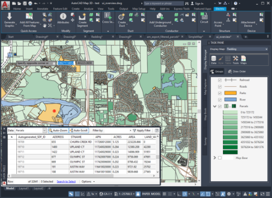 Support for high-resolution monitors continues to be improved in the Update. Over 200 dialog boxes and other User Interface elements have been updated to ensure a quality viewing experience on high-resolution (4K) displays.
Features of Autodesk AutoCAD Map 3D
- Proper range of 8 Minnesota County coordinate systems
- Support for Australian GDA 2020
- Deprecated 221 Wisconsin County HPGN coordinate systems
- Update to EPSG 9.0
- Support the transformation from OSGB1936 to ETRS89
- Added Deutsche Bahn Reference System and related coordinate systems
- New Version Support for FDO Oracle Provider
- High Resolution (4K) Monitor Support
- Fourth Generation MrSID Image Support
- PostGIS 2.2 Support
- AutoCAD Map 3D supports the WFS 2.0 protocol
- Amber Core Point Cloud Removal
- Extend the support of FDO ArcGIS Provider to versions 10.3.1 and 10.4.
Customer Reviews
You may also like




Reviews
Clear filtersThere are no reviews yet.